2025 Pacific Cell Friends of the Pleistocene Field Conference
Ridgecrest, California
When: 24-26 October 2025
The guidebook available if one scrolls down.
Save the Date Announcement
Save the Date! Friends of the Pleistocene: Searles Valley Field Trip Oct 24-26, 2025
Dear colleagues,
We’re excited to announce the 2025 Annual Meeting of the Friends of the Pleistocene in Searles Valley, California happening October 24-26! This trip will revisit the 2019 Ridgecrest rupture zones and explore new data from paleoseismology, satellite mapping, shoreline chronologies, and deformation along the Garlock fault system.
Confirmed trip leaders include Steve Bacon, Ian Pierce, Sally McGill, Colin Chupik, Chris Madugo, Kathleen Rodrigues, Maggie Duncan, Fred Phillips, Chris Milliner, Ken Hudnut, and Zac Smith. We’re still recruiting additional leads—let us know if you’d like to contribute.
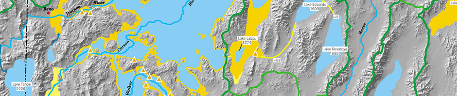
Our stops will include Searles Valley shorelines and lacustrine history, paleoseismic trenches, 6-year-old surface ruptures, and key Garlock fault offset sites. We have a plethora of new luminescence ages to share.
Guidebook contributions are due September 15. If you’d like to write up recent work, lead a stop, or help in any way, reply to this email or reach out to Ian or Steve.
Mark your calendars and get ready for a fantastic long weekend in the Mojave!
-Ian, Steve & the Searles Valley Beach Club
Announcement 2! (with registration details).
Ridgecrest 2025 – Friends of the Pleistocene Field Trip – Announcement 2
October 24–26, 2025
Searles Valley, California
Join us for the 2025 Friends of the Pleistocene field trip, exploring Searles Lake, the 2019 Ridgecrest earthquake ruptures, and the Garlock fault.
REGISTRATION & PAYMENT LINK: https://forms.gle/QpwgCPZ1GgB1zNPA7
Highlights include:
- New ages revealing the Holocene & late Pleistocene history of pluvial Searles Lake
- Field discussions led by geoscientists who studied the 2019 sequence in real time
- Examination of Mw 6.4 and Mw 7.1 paleoseismic sites and associated deformation
- Exploration of Garlock fault slip-rate sites
- Camping under desert skies with the Searles Valley Beach Club 2025 crew
Base camp: Will be located along the Trona Rd to the southeast of Ridgecrest, CA. Exact location TBD.
Trip Leaders: Steve Bacon, Ian Pierce, Sally McGill, Colin Chupik, Chris Madugo, Ozgur Kozaci, Kathleen Rodrigues, Maggie Duncan, Fred Phillips, Chris Milliner, Zac Smith, Ken Hudnut, James Dolan
Guidebook deadline: September 15, 2025
Contact: Ian Pierce (ipiercegeology at gmail.com) or Steve Bacon (Steven.Bacon at dri.edu) for contributions, logistics, or questions
Cost – $40 per person (paid via Venmo/Cash/Zelle/Paypal, details in registration form)
Itinerary Overview
Day 1 – Northern Searles Valley & 6.4 Rupture
The morning begins with a deep dive into the late Pleistocene & Holocene lake history of Searles Lake. We’ll examine shoreline sequences, sedimentary facies, new luminescence ages and preliminary lake-level curves that record highstands. These stops provide a regional paleoclimate framework before we pivot to tectonics. In the afternoon, we’ll transition to Mw 6.4 rupture sites to discuss UAV mapping, paleoseismic results, along-strike variability, and how satellite data guided field teams during the 2019 response, with stops highlighting both principal fault traces and distributed deformation.
Day 2 – Spangler Hills & Trona Pinnacles
The morning features a visit to a splay fault outcrop and the spectacular Trona Pinnacles tufa towers, with discussions of PBRs (precariously balanced rocks) and Quaternary lacustrine deposition. In the afternoon, we’ll hike to a trench site along the Mw 7.1 rupture, examining evidence for as many as 5 repeat events and rupture morphology. The day wraps up with roadside observations of additional paleoseismic sites in the Spangler Hills area.
Day 3 – Garlock Fault & Surroundings
Our final day focuses on slip-rate and paleoseismic sites along the Garlock fault. Discussions will cover long-term slip history, offset fan measurements, and implications for fault system behavior.
Thank you!
Ian, Steve & the Searles Valley Beach Club
Announcement 3! (with camping details).
Here is the camp location:
Camp is an undeveloped dry campground. We will provide portable restrooms. Pack out everything you pack in. No water is available on site.
From Trona Rd turn west onto Searles Station Rd (dirt). Drive 0.75 miles, camp will be on the right.
Alternatively, if heading northeast on Searles Station Cutoff (immediately after intersection with railroad tracks/ map labeled ‘Searles’), turn right onto Searles Station Rd. Main dirt road initially heads southeast, then broad left turn to head east-northeast. Follow this main dirt road for 2.0 miles, camp will be on the left.
The field trip begins 10/24 Friday morning. We encourage you to arrive the night before (Thursday 10/23 afternoon/evening).
We are still accepting preregistrations. We ordered a number of extra shirts, however registrations at this point are first-come, first-served for shirts. The vendor I used has an option for drop-shipping individual shirts so if we run out of shirts that is an option that can be explored for those left wanting.
There was a significant rain event in Ridgecrest a few weeks ago (between 2-4” of rain in 24 hrs). This took out highway 178. We believe based on the Caltrans website it has been reopened (Google still shows it as closed). We do not know the status of other roads in the field trip area. I expect some will be fine, some might be more challenging.
We are going to try to redo the route recon before the trip starts. We aim for all stops to be reachable in a 2wd car so will adjust routes as needed, regardless there will be a lot of gravel road travel so higher clearance might be nice to have.
We will be visiting fragile surface ruptures. Please avoid trampling these. We will also be in a pristine desert environment. Please pack out all of your trash and leave no trace. Bring plenty of water, a good hat (and possibly sun umbrella) as the sun can be intense even in late October and there is no shade. We will not have restrooms available at the stops, so plan accordingly (bring a shovel). There are restrooms at the Trona Pinnacles. Nights will likely be cold, so dress warm, bring a warm sleeping bag, and please help bring some firewood if you have the ability. Cell service is spotty, we recommend having satellite maps cached (The Strabo spot and Caltopo apps have great options for this, and Caltopo has the option to cache lidar data if you are inclined).
Preloading/saving the stop locations is a good idea. Particularly on Day 1, please take care crossing Highway 178 (several turns onto/off of this
highway) as there can be very high-speed traffic. Also take care crossing uncontrolled railroad crossings along the Pinnacle Rd. On dirt roads there may be OHV traffic (motorcycles, side by sides, ATVs, etc.), watch for these as they may be traveling at high speed. The closest fuel stations, groceries, ice, medical services, and other facilities are in Ridgecrest. Trona has limited services, but should have gas.
Some responses to FAQ’s from registrations:
-Kids, +1’s all welcome. If they need a shirt, please pay registration fee and note these are first-come, first served as above. Please keep underage folks away from adult beverages.
-We are only providing restrooms in camp. We have ordered 8 portable toilets. There may be restrooms available during the trip in Trona (Day
1) and a pit toilet at the Trona Pinnacles (Day 2).
See you soon
-Ian
Announcement 4! (GUIDEBOOK).
Here is a link to the GUIDEBOOK
Main Pages
Sign up for the email list for email notifications.